November 2026 Newsletter
A Word from our President

by – Tom Tallon-Alpha HVAC & Plumbing
As we look ahead to the upcoming months and the busy heating season, we want to take a moment to express our sincere appreciation to all of our HVAC contractors. We are truly thankful for the continued support, the work coming in, and the opportunities we have to serve and support your businesses. Your involvement and dedication are what make our association strong. We would also like to welcome new members to KCCA! If you are a licensed HVAC contractor and have not been a member, now is the perfect time to join. New members receive a FREE one-year membership! We look forward to growing together, building relationships, and making this a successful season for everyone.
Tom Tallon-Alpha HVAC & Plumbing
Please feel free to contact me with any questions,
tomt@alpha-heatair.com or Office 316-260-5775



MABCD Newsletter
Click here to get the latest updates on Mechanical, Electrical and Plumbing changes to code.
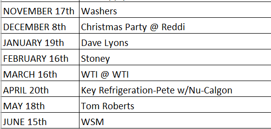
2026/2027 Meetings
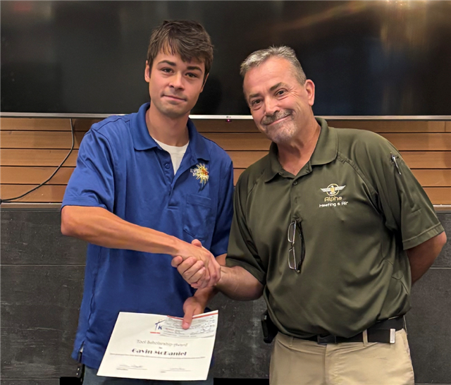
October’s General Meeting
Last months general meeting we had Andrew Quoos from Prism Sales to show us some awesome new tools out there in the industry. Another month with a great turn out for the speaker. We had some new faces in the room and everyone got a 1hr CEU hour.
Hope to see you @ future meetings!! All general meetings are held on the 3rd Tuesday, except no meeting in July or December.
2026-2027 Winter Weather Forecast
A strong El Niño could mean less heating demand in some regions, while cold snaps, heavy snow, and storms could keep HVAC contractors busy elsewhere.
By Dylan Kurt
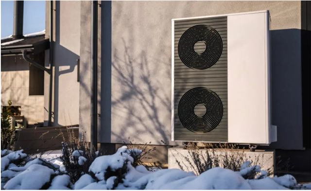
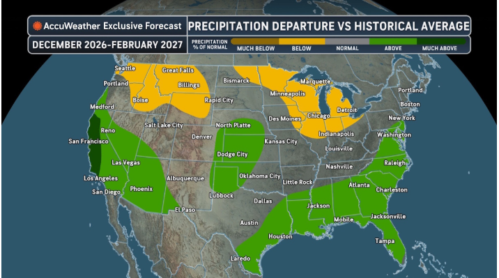
A historically strong El Nino event is set to grip the United States this winter, tilting the long-term forecast toward a more mild heating season across much of the northern portion of the country, while increasing the potential for a wetter, stormier season across portions of the south.
But that doesn’t mean HVAC contractors should expect an uneventful winter — forecasters said other atmospheric and oceanic factors could complicate the typical El Niño pattern, creating opportunities for early-season cold, bouts of heavy precipitation, and potentially significant snow or ice events even in areas expected to finish the season warmer than normal.
“El Niño will be a dominant signal in this upcoming winter season forecast,” said Paul Pastelok, senior meteorologist and lead long-range forecaster at AccuWeather. “This will be a very strong El Niño and could be record setting.”
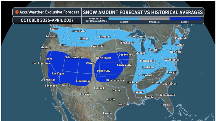
El Niño typically strengthens the southern storm track, increasing precipitation across parts of California, the Southwest, southern Plains, and Southeast while leaving portions of the northern U.S. warmer and drier. But Pastelok cautioned that this winter’s outcome will also depend on several other factors, including marine heat waves in the Pacific, the position of the Aleutian low, Canadian snowpack, and the polar vortex.
Sarah Perreault, managing editor of The Old Farmer’s Almanac, is also expecting a generally mild winter, though not everywhere.
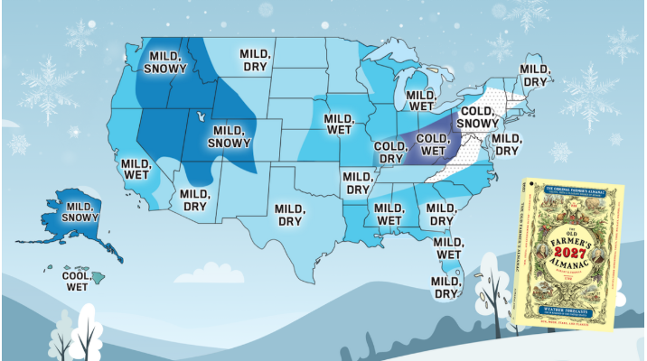
“A milder winter doesn’t mean cold temperatures are taking the year off,” Perreault said. “Across much of the country, temperatures are expected to be near normal or warmer than normal. But colder-than-usual temperatures are expected from central New England south through the Appalachians and into the Ohio Valley.”
Jon Gottschalck, chief of the operational prediction branch at NOAA’s Climate Prediction Center, also warned that “enhanced storminess may produce events of heavy precipitation, high winds and flooding across the southern tier of the U.S. and along the eastern seaboard,” bringing the potential for elevated power disruptions.
And even within areas forecast to be relatively mild, periods of cold could still produce bursts of heating demand. Pastelok expects “a little more heating used in part of November with an early potential surge of chill,” particularly around the Great Lakes and Northeast, before warmer conditions become more dominant during December and much of January.
Below is a region-by-region long-range forecast: of note, Perreault made sure to mention that “above normal” is relative, and Gottschalck said that NOAA does not officially make seasonal snowfall forecasts.
Northeast
ME, NH, VT, MA, RI, CT, NY, NJ, PA
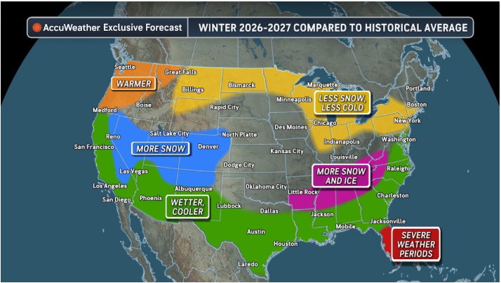
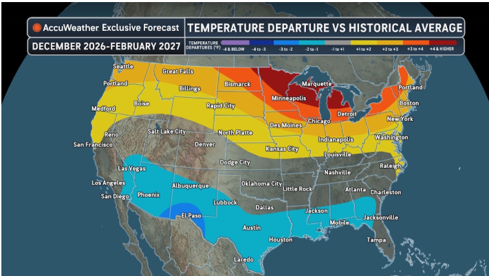
AccuWeather: Temperature departures compared to historical averages will range from 2-5°F across upstate New York and northern New England. Heating demand will be much less than previous years. Departures will be above average in the rest of this region, but not as extreme. Still less heating demand is expected, with some surges during the month of December and January especially.
Most areas will see less-than-average snowfall this winter. An exception can be the northern mountains of New York State and New England that can be closer to average. The risk is more snow from any potential Nor’easter timing out with cold, which has a higher chance in late January or February.
It can be a wet winter season, with a few strong storms that can lead to coastal flooding and beach erosion. But rain could be more frequent than snow with these storms. That can raise the flood threat, especially for southern New England, Pennsylvania, and New Jersey.
“This can be a wet winter season for some, with above-average temperatures overall. But watch for storms taking a turn and intensifying just off the coast,” Pastelok said. “Snow or mixed precipitation is possible mainly away from the coast. There can be coastal flooding. But late January and February is a risk period for snow.”
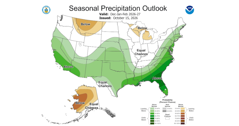
NOAA: Above-normal temperatures and above-normal precipitation for coastal states and eastern interior states.
“NOAA does not officially make seasonal snowfall forecasts, but snowfall during strong El Niño winters is typically below normal for western parts of the Northeast,” Gottschalck said.
OFA: The southern part of the Northeast will experience a more difficult winter, with below-normal temperatures and above-normal snowfall. Coldest periods: Early and mid-January. Snowiest periods: Mid- and late December, mid-January, and early and late March.
Mid-Atlantic
MD, DE, VA, WV, NC
AccuWeather: This area will run above average on precipitation. All three months, especially across North Carolina, Virginia, Maryland, and Delaware, can deal with frequent cold fronts, stalling at times, with storms running north along the fronts bringing heavy precipitation, mainly rain early on in the season, especially.
More mixing events can hold down snow amounts across Maryland and Virginia. Near to perhaps just above average.
But there can be occasional power outages from wind and mixing events. Flooding is likely across Virginia and possibly for Maryland and Delaware. A few big storms (nor’easters) can lead to coastal flooding.
Temperatures will average close to normal but leaning slightly above for this region. Arctic surges are not expected on a frequent basis.
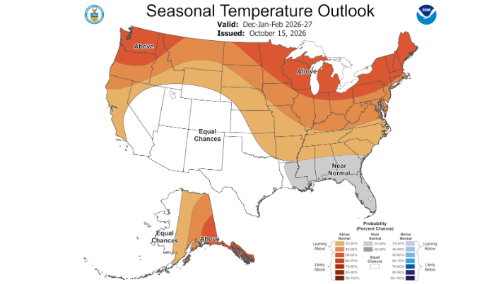
NOAA: Above-normal temperatures and above-normal precipitation. Seasonal snowfall departures from normal during strong El Niño winters are typically above-normal in this region.
OFA: A milder winter is in store for the Atlantic Corridor, with above-normal temperatures and slightly below-normal snowfall. Coldest periods: Early to mid-December, early to mid-January, and early and late February. Snowiest periods: Late November, early and mid-January, early and late February, and late March.
Southeast
SC, GA, AL, TN, KY
AccuWeather: Above to much above average precipitation expected this winter. Each month has a good shot of above. Temperatures will be held down with clouds and moisture. Near-average temperatures are expected early in the winter, but actually fall below average later in the fall with some chilly shots following storms along the East Coast.
Some snow or ice is possible on northern edges of storm tracks across northern Alabama, northwest Georgia, Tennessee, and southern Kentucky. We are expecting at least 2 snow or ice events. Snow and ice averages are low, so it will only take 1-2 storms to reach average; then any more would push this region to above average. This area is at moderate risk for power outages, mainly over the mid- January to February period.
“Stalled cool fronts and storms forming along these fronts can lead to excessive rainfall that leads to flooding. Flooding can cause concerns to basements or lower-level floors where heating systems are located,” Pastelok said. “This will be a busy area, with one of the multiple storm tracks centered in this region. Flash flooding and severe thunderstorms can occur in this region. Severe thunderstorms producing tornadoes are possible from Georgia to North and South Carolina. We have seen this occur in past strong El Niño events.”
NOAA: Above-normal temperatures most likely for TN, KY, northern AL and GA, and SC. Near-normal temperatures are favored for southern AL and GA. Above-normal precipitation except for KY and most of TN with EC in remaining areas. Parts of this region have the highest likelihood for wetter-than-normal conditions. Seasonal snowfall departures from normal during strong El Niño winters are typically above-normal in this region for TN, northern AL, GA, and SC.
OFA: Southern portions of the Southeast region will have a milder, drier winter, with above-normal temperatures. Coldest periods: Mid-November, early and mid-December, early January, and late February. Snowiest periods: In the north, early January and late February.
Deep South
MS, LA, AR
AccuWeather: Moderate to higher risk for flooding for this region, especially southern and eastern areas. Heaviest rainfall can be in December and February. Temperatures will average near normal early in the winter, due to warmer waters in the Gulf. But these waters will cool, and the combination of that and more and more rainfall will hold temperatures, perhaps a degree or two below averages for January and February.
Southern Arkansas, northern Mississippi, and possibly northern Louisiana could be in line to get one or two snow or ice events, being on the northern edge of a storm track forced to the Gulf Coast.
“This area will be back and forth on precipitation rates,” Pastelok said. “They will be between many of the storms tracking off the East Coast and also across the central Plains. The strongest impacts from many of these storms may not be in this region with the exception of any ice event.”
NOAA: Above-normal temperatures most likely for AR and northern MS with near-normal temperatures for LA with above-normal precipitation except for KY and most of TN with EC (equal chances) in remaining areas.
OFA: Warmer-than-normal temperatures are on tap for the Deep South, with a few chances of snow in the north and wetter conditions to the south. Coldest periods: Mid-December, early January, and early February. Greatest chance for snow: In the north, early January and early and mid-February.
Florida
AccuWeather: Florida will average above on precipitation, but near to slightly below average by a degree or so in temperatures. A few severe weather events are likely this winter season, typical of an El Niño winter. Tornadoes can not be ruled out, again not that uncommon in El Niño winters.
“We are not expecting the extreme cold we saw last year in this area,” Pastelok said.
NOAA: Near-normal temperatures and above-normal precipitation. Northern FL has the highest likelihood for wetter-than-normal conditions. Elevated risk of late winter (February) severe weather.
OFA: A milder winter is on tap for Florida, especially as spring creeps nearer, while southern areas will see less rain overall. Coldest periods: Early and mid-December and early January. Wettest periods: Mid- to late January, late February, and early to mid-March.
Great Lakes
MI, OH, IN, IL, WI
AccuWeather: The frequency of arctic cold air masses will be lower-than-average. This can lead to less-than-average snow. The lake machine will be on less frequently. Precipitation will be less-than-average, especially across Indiana, Michigan, and Ohio. Temperatures are expected to be several degrees above average each month. Heating demand should be lower-than-average, possibly well less-than-average. Across the lower Ohio Valley, the departures will not be as high, closer to average.
“This will be a season of several storm tracks,” Pastelok said. “A storm track through the south-central Rockies into the central Plains could begin in January and continue at times into February. This can bring a little more snow to Illinois and areas west where snowfall could be near average.”
NOAA: Above-normal temperatures are most likely with EC for most areas for precipitation. Slight tilt toward below-normal precipitation for parts of MI and WI. See map. Seasonal snowfall departures from normal during strong El Niño winters are typically below normal in this region.
OFA: Despite being warmer than normal and less snowy, Lower Lakes conditions will still prove difficult, with above-normal precipitation and a classic winter January. Coldest periods: Early January and early February. Snowiest periods: Early and late January and early February.
Upper Midwest
MN, IA, ND, SD
AccuWeather: Across northern Minnesota and North Dakota, temperature departures can be above to well above average and precipitation below. Snowfall can average below as well. For Iowa and South Dakota, temperature departures can still average above, but closer to average. Cool downs can be more noticeable in January and February. Snowfall in Iowa and South Dakota can be closer to average with a developing storm track mid to late winter.
NOAA: Above-normal temperatures are most likely with EC for most areas for precipitation. Slight tilt toward below-normal precipitation for parts of ND and MN and above-normal precipitation for parts of SD and IA. See map. Seasonal snowfall departures from normal during strong El Niño winters are typically below-normal for ND, SD, and MN.
OFA: Expect milder months in the Upper Midwest to transition to colder-than-normal temperatures as winter continues. While snow will be near to below normal, there are many chances for flakes to fly in the new year. Coldest period: Mid- to late January. Snowiest periods: Early and late January, late February, and early March.
Central Plains
MO, KS, NE, OK
AccuWeather: Not super cold or consistently cold. Temperatures will average near normal. Precipitation across Kansas, Oklahoma, and Nebraska will average above and near to slightly above on snowfall. January and February can be the more active months and cooler months. December can be a wet month in Missouri, above average, then closer to average in January and February.
“In January and February, we need to watch for a potential ice or snow event in eastern Oklahoma and southern Missouri being so close to the southern storm track,” Pastelok said. “Western Oklahoma could have several storms with mixed precipitation.”
NOAA: Above-normal temperatures for MO, eastern KS and OK, and most of NE with above-normal precipitation for the region except for eastern MO. Seasonal snowfall departures from normal during strong El Niño winters are typically above-normal for KS and OK.
OFA: The Central Plains will be warmer and wetter overall, with near- to below-normal snowfall. Coldest periods: Early and late January and early March. Snowiest periods: Early December, late January, and early March.
Texas
AccuWeather: Texas will use a little more heating this season compared to the historical average. Temperatures will run a couple of degrees lower-than-average, and this can be spread out through the winter season. Precipitation will average above in the eastern part of the state and northwest part of the state. In between, precipitation will run near to slightly above average. Snow or ice can average near to above in the northwest part of the state.
“Risk is that precipitation is higher far north and east of the state based on a couple of more recent El Niños,” Pastelok said. “We are actually more conservative compared to several past El Niños.”
NOAA: EC for temperature but above-normal precipitation most likely with the highest likelihood for northern and eastern parts of the state. Seasonal snowfall departures from normal during strong El Niño winters are typically above-normal for northern parts of the state including the Panhandle.
OFA: A warmer, drier winter is expected in Texas. There is a chance for snow in the new year! Coldest periods: Early and late January and early February. Greatest chances for snow: In the north, early and late January and early February.
High Plains and Rockies
MT, WY, CO, NM, eastern ID
AccuWeather: Precipitation will vary across this region. Northern areas can be drier (eastern Idaho, northern Wyoming, Montana). Anywhere farther south, temperatures will run 1-3 degrees lower-than-average, and snow and precipitation can run above. A busy storm track onto the West Coast can send storms into this region
“Similar risk to the forecast as was mentioned in the previous region. Farther north can be more active and southern areas less active if a repeat of the 2015-16 season occurs,” Pastelok said. “Water temperature anomalies in an area between Hawaii and Baja are running above average, and that could lead to upper-level conditions that are not favorable for a consistent storm track. But confidence is still low on this scenario.”
NOAA: Above-normal temperatures are most likely for MT, most of WY and ID, with EC for NM and CO. Below-normal precipitation is most likely for MT and parts of ID, with above-normal precipitation most likely for most of CO and for NM. Seasonal snowfall departures favored to be above-normal during strong El Niño winters for NM and for SE CO, with below-normal seasonal snowfall most likely for most of MT, ID, and WY.
OFA: Warmer and drier conditions are expected in the High Plains, along with below-normal snowfall. Coldest periods: Early and late January and early and late February. Snowiest periods: Late January and mid-March.
Southwest
AZ, NV, UT, southern CA
AccuWeather: Leaning toward a very active winter season, starting in late fall and running through March. Snow in the mountains should run above average, with a high frequency of snow days. Rainfall in the lower elevations will run above average, with some flooding and mud-flowing rivers. Temperatures should be below average by 1-3 degrees from December through February, with more demand for some heating.
“Moderate risk for flooding,” Pastelok added. “The only reason this is not high is that the risk, as mentioned in the previous two sections, is how strong the southern storm track will be and the position.
NOAA: EC for temperature except for above-normal temperatures for NW NV. Above-normal precipitation for southern CA, AZ, and southern UT. Seasonal snowfall departures favored to be above-normal during strong El Niño winters for northern AZ, southern NV and UT.
OFA: Expect a mild winter in the Desert Southwest, with warmer and drier conditions, including in areas that usually receive snow. Coldest periods: Early and late January and early February. Snowiest periods: In areas that receive snow — early January and late February.
Pacific Northwest
WA, OR, western ID
AccuWeather: Across Washington, central and northern Idaho, precipitation can run below average and temperatures above average by 1-3°F. Farther south, the forecast is a little more uncertain. November and December can run near average on precipitation, but temperatures will still run above. Southwest Oregon can run above average on precipitation in December and January and not as warm, running closer to average.
“Water temperatures in the northeast Pacific and off Baja could force a more active storm track into this region, especially in November and December,” Pastelok said.
NOAA: Above-normal temperatures are most likely with EC for precipitation except for southern OR where above-normal precipitation is favored. Seasonal snowfall departures are favored to be below-normal during strong El Niño winters for this area.
OFA: Expect above-normal temperatures in the Pacific Northwest and, to no one’s surprise, a wet winter with above-normal snowfall. Coldest periods: Late December, early January, and early February. Snowiest periods: Late December, mid-January, and mid-February.
Alaska
AccuWeather: Near to above average precipitation is expected in the farther southern part of the state. The rest of the state will average near to below average precipitation. Temperatures can run warmer-than-average across the central, northern, and eastern part of the state. Southern and western areas can be closer to average. Snowfall for the state overall can run below average.
NOAA: Above-normal temperatures are most likely for the eastern part of the state, with below-normal precipitation favored for the northern two-thirds of the state. Seasonal snowfall departures favored to be below-normal during strong El Niño winters in the northern two-thirds of the state.
OFA: While it will still be cold in Alaska this winter, temperatures will be above normal overall, with more snow compared with average. Precipitation will be above normal in the north but below normal in the south. Coldest periods: Late December, mid-January, and mid-February. Snowiest periods: Mid-November, early and late January, mid-February, and late March.
Hawaii
AccuWeather: Below to well below average precipitation for the northern and western Islands with near average temperatures. In southern areas of the Islands and the Big Island, precipitation can be near to slightly below average with near to above average temperatures.
NOAA: EC for temperature with favored below-normal precipitation.
OFA: Hawaii will experience cooler-than-normal temperatures, but not dramatically so. Rainfall will be above normal, especially in the east later in the winter. Coldest periods: Early to mid-November, early December, late January through early February, and early March. Stormiest periods: Mid-December and mid-January, as well as late February and much of March in the east.
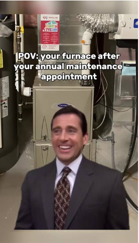
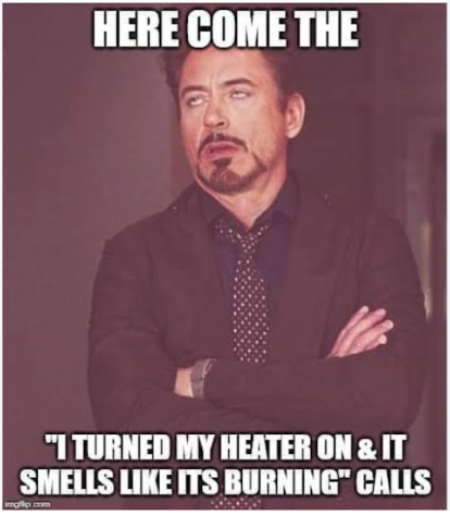
Funny Photos

Monthly Fire Checks Can Help Your Business Stay Flame-Free
During Fire Prevention Awareness Month each October, it is important to remember that workplace fires do more than damage property. They endanger people, disrupt operations, release pollutants into the environment, can cause serious losses, and may lead to permanent closures. In fact, 40% of businesses fail to reopen after a catastrophic event, such as a fire.1
Keep Your Fire Risks in Check
Take fire safety a step further at your business by assigning a key staff member to conduct a monthly walkthrough of your facilities with a fire prevention checklist. This can help you monitor common causes of fires, including poor housekeeping and deferred equipment maintenance. It’s also a good way to regularly evaluate electrical systems and appliances, keep evacuation routes clear, and confirm fire protection systems are in good working order.
Plus, walkthroughs can help your team identify and resolve hazards threatening the business before a fire sparks up. If you have multiple locations, be sure to assign a trusted employee to walk through them with a checklist. This proactive approach can make a difference in enhancing general safety and teaching good habits.
Make Fire Prevention a Priority
Fire Prevention Awareness Month will come and go, but fire hazards are ever present. Making routine checklist-driven walkthroughs part of your workplace culture can make a lasting difference in your business. Reach out to your local Federated Insurance® marketing representative to learn more about risk management resources, including a fire prevention assessment checklist. Federated® clients can also access mySHIELD® for sample safety meeting guides, fire prevention handouts, and more.
1. Access. Study: 40% of businesses fail to reopen after a disaster. https://www.accesscorp.com/press-coverage/study-40-percent-businesses-fail-reopen-disaster/. Accessed August 11, 2026.